Rivers Rejuvenated

Sairni River
The catchment area of Sairni river is 237 sq km. Its meandering length from the origin of the river to the Aangai Dam is 35 km. A total of 150+ water structures have been constructed in the river basin by Tarun Bharat Sangh with community participation.
In the world geo-map, the Sairni river catchment area is located between 26°33’00” to 26°45’00” north latitude and 76° 13’00” to 76° 26’00” east longitude.
The origin of Sairni river starts from the northern part of village Kheda in Masalpur tehsil of Karauli district. Further this stream moves forward towards north-east. Going forward near Mardai Kalan, on one side the water from Bhudkheda and Maharajpur villages get mixed and on the other side the water of the eastern slope of Masalpur and Rundhpura etc. and other villages also gets merged. Further, the water of Sandan ka Pura, Khoonda, Arounda and Dawoodpur villages also gets merged. The water of Garh Mandora village and the forest also gets merged at the same place. Further moving some distance in the northeast, this river turns to the southeast, fills the Angai dam and moves forward. From here the name of this river becomes Parvati-river. Parvati river joins Gambhir river which further joins the Yamuna River. Yamuna river joins Ganga river at Prayagraj (Allahabad) and Ganga river finally merges into Ganga Sagar.
Tevar River
The catchment area of Tevar river is 42 square kilometers from Kot Pasela to Naharpura. Its meandering length is 13 kilometers. A total of 18 water structures have been constructed in its catchment area by Tarun Bharat Sangh with community participation till 2018.
In the world geo-map, the Tevar river catchment area is located between 26° 21’38” to 26°26’13” north latitude and 77° 11’25” to 77° 16’00” east longitude.
Tevar River originates from several villages located in different directions. On one side the water of three Pokhar villages comes in this river, on the other side the water of Rajpur, Kot, Pasala, Paselia, Bagoria, Hallipura, and Manakhur comes. This water goes from south to north. Further, after going 6 kilometers ahead of Naharpura, this river joins the Goder river and the Goder river joins the Parvati-river. Parvati river joins Gambhir river and Gambhir river joins Yamuna. The Yamuna River joins the Ganges River at Prayagraj (Allahabad) and the Ganges River finally merges into the Ganga Sagar.

Jahajwali river
The catchment area of Jahajwali river is 89 square kilometers. Its meandering length from the origin of the river to the Mangalansar dam is 20 km. A total of 126 water structures have been constructed in its catchment area by Tarun Bharat Sangh with community participation.
In the world geo-map, the Jahajwali river catchment area is located between 27° 11’39” to 27° 18’21” northern latitude and 76° 24’15” to 76°31’20” east longitude.
The Jahajwali river passes from east to west Guvada, Bankala and Deori villages and goes to the top of the pilgrimage place called Jahaj. Further this river turns south and falls down. The place where it falls down, is called Dahda (Dah). After walking a little further, another stream coming from west to east joins it. Further moving towards the east and and then to the south, near the Nandu village, the water from the forests of Rada and Nandu villages also joins. A stream coming from the northern side forest of Ghevar and Nayala, joins the main stream of this river near Murlipura from the south. Another stream flowing from the mountains of Losal Gujran joins the main river between Chava Ka Bas and Ghevar. Some drains running from Losal Brahmnan and the eastern forest of the Talaab merge into the Mangalansar dam near Tehla. In these streams, another sub-streamfrom the south of Talaab village fills the village pond from the north.. After the pond is filled, this sub-stream joins the above drains and joins the main stream of the river Jahaj . Two streams from the north of Rajdoli and Rupbas villages meet in the “Guyalya Dam” built in Tehla’s fields towards the south. The water from this dam also merges in the Manglansar dam of Tehla. Upto here the complete area is called as “Jahajwali River.” Going a little further than this, this stream joins the “Bhagani River”. The joint stream of Jahajwali river and Bhagani river is called “Tildeh river” details of which are further given in Bhagani-Tildeh river.
Bhagani Tildeh River
The catchment area of this river is 296 square kilometres below Radia Dam till Triveni Sangam. It also includes the catchment area (89 sq km) of “Jahajwali River”. The total meandering length of the Bhagani-Tildeh river (excluding the Jahajwali river) is 49 km. A total of 120 water structures have been constructed by Tarun Bharat Sangh with public community participation in this catchment area (besides Jahajwali river).
Bhagani – Tildeh river watershed catchment area (except Jahajwali river) in world geo map is located between 27° 05’02” to 27° 21’51” north latitude and 76° 19’16” to 76° 27’45” East longitude.
The main stream of the Bhagani-Tildeh river, starting from the southern side to the west of the western mountain of Garh (Neelkanth), flowing towards the north first fills the Bhomiya ji dam of Mandalwas. Another stream starts from the south of Mandalwas village and flows towards the north, and goes a little ahead of Mandalwas and joins the main stream that came coming out from Bhomiya Ji dam. Flowing in the north direction, this joint merged stream reaches Rajour, Mathuravat, Manyala and Kanyawas, turns a little towards the east and then turns towards the south. Then flowing down in the south, this stream merges with the stream coming from Kankwadi, turns towards Chowki Wala and falls into Mansarovar after passing through Misrala. Many small and big drains flows into it on the way. Another stream coming from south towards north of Garh village, turns east and fills the princely dam “Ramsagar” of Garh and turns north-east and joins Mansarovar below. Apart from this, the water from the entire forest of Dabkan also goes to Mansarovar in the end. Till here the name of this river remains “Bhagani river” only.
Further from here, “Jahajwali river” also joins it near Mallana village. Beyond this confluence, the name of this combined river becomes “Tildeh River”. On one side of Tildeh, water from villages like Mallana, Govardhanpura, Rampura, Kankrali etc. comes; on the other hand water comes from Tilwadi, Tilwad, Palpur, Parasharji, Sakkala, Khoh- Dariba etc. villages. Downstream, the water from villages such as Berli, Jaisinghpura, Budhpura, Asan, Ghatda and Rediya etc. also enters this river. Filling the Redia dam, this river takes the name of “Saanwa river” after joining the joint stream of “Sarsa” and “Arvari” rivers at the Triveni confluence between Nangal Dasa and Redia. Saanwa river joins Banganga which joins Gambhir and joins Yamuna-river in the name of “Utangan river”. The Yamuna River joins the Ganges River at Prayagraj (Allahabad) and the Ganges River finally merges into the Gangasagar.
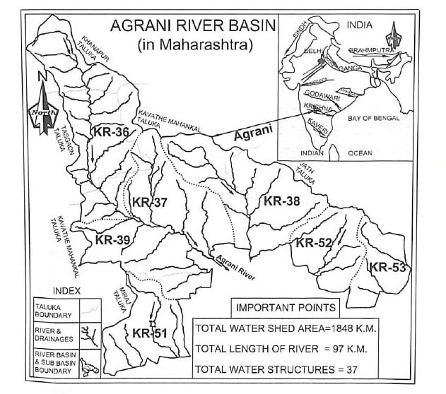
Agrani River Basin
Agrani River Basin Rejuvenation Resolution – Jal Biradari: The Agrani River Basin Rejuvenation Project’ was started by Jal Biradari in 2014. Agrani River is an interstate river, which is a 97 km long tributary of Krishna, the fourth largest river in India. The Agrani River basin catchment area is spread over an area of 1848 sq. km in 5 tehsils of Sangli district of Maharashtra and 149 villages in one of the tehsils of Karnataka. This river is spread in 5 tehsils of Sangli district of Maharashtra: Khanapur, Tasgaon, Kavathe Mahakal, Miraj and 107 villages of Jat tehsils and 42 villages of Athani tehsil of Karnataka whose total population is 4 lakh 20 thousand. This can be understood properly through the following table.
| No. of Watersheds | KR-36 | KR-37 | KR-38 | KR-39 | KR-51 | KR-52 | KR-53 | 7 Watersheds |
| No. of micro- watersheds | 11 | 5 | 9 | 5 | 5 | 5 | 3 | 43 micro- watersheds |
| No. of villages | 34 | 15 | 20 | 16 | 10 | 9 | 3 | 107 villages of Maharashtra |
| Ground- water level | Over- exploited | Over- exploited | Semi- exploited | critical | safe | Over- exploited | Over- exploited |
It is clear from the above classification of watershed that ground water has been exploited in that area, as a result of which drought conditions have arisen there.
Objectives of Agrani River Rejuvenation Concept
To develop a paradigm of duties and responsibilities towards rivers as an ecological system against the mindset of rights over river water:
Objective: To motivate the communities to accept the river basin vision.
The community has been primarily focused on its rights related to water from the Agrani River, so surface and ground water have also been exploited. Also, there have been inter-state disputes over the sharing of water between communities located in the upper reaches of the river and downstream. Maharashtra Jal Biradari, in association with Karnataka Jal Biradari, has taken a unique initiative to connect the communities living on both sides of this river.
Comprehensive technical data like river basin maps, watershed maps, micro watershed maps, geological structure of the river basin, availability of water, recharge zone maps of each village, water budget of each village, this sharing of information has helped communities become more aware and sensitive towards the river. Community members are beginning to realize that we are part of a river basin and a larger eco-system where the demands of various stakeholders are seen in proper perspective.
Agrani Seva-Dal (a group of youth sensitive to the river): Seva Dal along with “Jal Biradari” undertook a 97 kms. long foot march along the stretch of the Agrani river to identify recharge zones and identify types of aquifer-fractures and underground sources of hydroelectricity were studied. This scientific and technical data was integrated with local conservation, traditional knowledge of water conservation and management, testing and a detailed project report of possible works for integrated development of this sub-basin was made.
The implementation of various components of water conservation as detailed in this report is being done using the combined resources raised by the community, local government and corporate and social responsibility funds.
Activities, achievements on the action points proposed in the DPR:
Creating detailed digital value maps of Agrani River basin: Creating maps depicting watersheds, micro-watersheds, rivers, water bodies and existing water conservation structures which shows geological rock-formations and their relation to water circulation, rain water-recharge potential and other relevant geological features of each village in this river basin. Current cropping pattern of land use and local and temporary rainfall data compiled.
- 37 small rain water harvesting structures have been built in the series on the river, at present the work is in progress.
- To protect the banks of the river from corrosion, the width and depth of the river were increased, stone pitching, bamboo and grass plantations were
- The fertile soil released during the widening and deepening of the river was spread on barren and waste land to increase the soil fertility.
- Continuous contour trenching, deep contour trenching, small ponds, other water- structures, intensive plantation and afforestation were done for forest land treatment.
- The soil, climate and conditions of the Agrani River basin is suitable and favorable for the development of Kesar 40,000 kesar mango saplings were planted (target of 5 lakh saplings) to increase farmers’ income.
- To revive the wells and borewells of all the villages falling in the river area, they are being linked to rain water harvesting.
- Agrani river parliament will be formed as a river valley-based organization by gathering youth sensitive towards the river in 149 villages located in the river area; whose responsibility will be to keep the river eternal.
The leadership values and principles of the Jal Biradari are the guiding force behind the progress of Agrani River Valley’s work. Collaboration between local communities, administration, water experts and philanthropists providing financial support is key to achieving success reflected on the ground.

Sarsa River
The straight distance of this river from Gudha Kishordas to Sarsa Devi Temple i.e. from north to south is 28 kms and the curved length is about 32 kms. From Sarsa Devi Temple to Triveni Sangam ahead of Nangal Dasa, the straight distance of the river from west to east is 11 kilometers and the curved length is about 13 kilometers. In this way, the curved length of Sarsa river from Gudha Kishordas to Nangal Dasa till Triveni Sangam is about 45 kilometers. The total catchment area of the Sarsa River is 279 square kilometers. A total of 274 water conservation structures have been constructed in this catchment area by Tarun Bharat Sangh from 1985 to 2018 with community participation.
In the world map, Sarsa river catchment area is located between 27° 03’54” to 27° 21’1” north latitude and 76° 13’36”to 76° 30’44” east longitude.
The Sarsa river starts from Angari and Gudha Kishordas and flows through Jaisinghpura, Dera, Bamanwas Kishori, JaitpurBrahamnan, Ajabgarh, Mandir Sarsa Mata, Dhiroda, Lilya, Kitla, Syaluta and Nangal Dasa and merges into the Arvari river originating from Sainthal Sagar. Different sub-streams coming from different directions merges in this main stream of Sarsa river. Two drains of origin villages of Angari and Gudha Kishordas form the main stream near Jaisinghpura. A drain starts from Bisuni joins the main stream near Dear. Between Bamanwas and Kishori, five drains join the Sarsa river at different places. One of them comes from Suratgarh, one from Kyara, one from jungles of Shyampura, one from Nimaala, and one from Raipura-Bhaal. The water from Gopalpura, Govindpura, Bhikampura, Jaitpur-Brahamnan and Daulatpura villages merges in Sarsa river at different places. A sub-stream filling the Kalana Dam with the water from Piplai, Kalapara and Mordi joins the main stream of Sarsa beneath the Jaitpur Brahamnan dam.
Apart from this, the water from 27 Guwadas of Ajabgarh and the forest also merges in Sarsa river through big and small drains. A large drain from the forest of Gugli Ka Guvada meets directly in Jaisagar dam of Ajabgarh. Built between the western hillocks of Jaisagar Dam, princely dam of “Som Sagar”also merges with Jaisagar after getting filled. The water from the slopes between Jaisagar and Sarsa Matamerges in the main stream of Sarsa river. From its origin till Sarsa Mata temple, this river flows from north to south. Then beyond Sarsa Mata temple it flows from west to east. The water from Bhangarh, Gola ka Bas and Dhiroda also merges in the main stream. Further the water of Lilya, Keetla, Nangal Chandel, Lankash, Paota, Narayani Mata, Baldevgarh, Syaluta and Nangal Dasa drainsalso merges with the main stream of Sarsa at different places.
The Sarsa river joins the Arvari river near Nangal Dasa. Then after going half a kilometer ahead of, it, this combined rivermerges the water of Jahajwali river and Bhagaani-Tildeh river in it, joins it in Banganga near Bandikui under the name of “Saanwa river”. Banganga merges with Gambhir river and then with Yamuna under the name of Utangan river.. The Yamuna River merges in the Ganga River at Prayagraj (Allahabad) which later drains into the ocean.

Arvari River
The straight distance from the upper village of Kanker ki Dhani to Sainthal Sagar in Arvari river is 35 kms and the curved distance of the river is 45 kms. The catchment area of the river is 492 square kilometers. A total of 402 water conservation structures have been built by Tarun Bharat Sangh with the community participation in the catchment area from 1985 to 2018. On the world map, Arvari river is situated between 27° 00’37.5”– 27° 20’57” northern latitude and 76° 04’15”- 76° 17’36” eastern longitude.
Arvari river originates in Thanagazi tehsil of Alwar district and Jamuwa Ramgarh tehsil of Jaipur district and a small part of Viratnagar located in the northeastern part of Rajasthan. One stream of Arvari river starts from Kankad ki Dhani and Dholi Danti-Seva ka Guwada near Aagar village of Thangazi tehsil and the other stream starts from Bhanwta-Kolyala (Bhuriyawas) and moves further in the south direction. Another stream starts from Jodhula village of Viratnagar tehsil, passing through Amka, Padaak, Chhapli villages of Thanagazi tehsil, merges with the stream coming from Aagar near Chausla village. This stream merges with the second main stream of the Arvari river, which starts from the villages of Darolai, Nagel and Madhogarh etc. and flows through various drains to the famous place “Shiv Dahda” in the west of Pratapgarh in which the stream coming from Lothwas and Palasana is also present merges near Chandpura. A little further, the stream coming from Bhanwta-Kolyala also joins in. The combined stream now starts flowing towards south. After crossing Hamirpur, the river joins the streams coming from Khardata, Dumoli, Jhiri and Jagannathpura near Samra villlage.
There is another main tributary of Arvari river, which is known as “Bidila”. It passes through Chilpili, Dhirawas, Bahlod, Chainpura and Raisar villages of Jamuwa Ramgarh tehsil of Jaipur district and flows ahead after filling in Kharadh dam. Another stream joins this dam from Samred and Mahangi sides. After filling the Kharadh dam, this tributary of Arvari river flows through Saipura, Aandhi, Thali and Jagatsar and finally joins the Sainthal Sagar.
After filling the Sainthal Sagar, the Arvari river passes through Nabhala, Sainthal and Pilwa villages and merges with another revived river “Sarsa River” near Nangal Dasa. Half a kilometer ahead this joint river also merges the Jahajwali and Bhagani-Tildeh rivers in it. From here onwards the name of this river becomes “Saanwa River”. The Saanwa river merges into the Banganga at 27° 02’35” north latitude and 76° 46’48” east longitude near Jhuthaheda, Kala and Baijupada villages near Bandikui. Banganga further joins Gambhir river near Bharatpur and flows with the name of “Utangan River” joining Yamuna river at 26° 59’01” north latitude and 78° 46’49” east longitude The Yamuna river merges with the national river Ganga in Prayagraj (Allahabad) and the river Ganga finally merges into Gangasagar to form an ocean.

Sabi River
The catchment area of the Sabi river in Rajasthan is 4350 square kilometers. Its total length from its origin Pithampur and Bari Jodi is 175 km. A total of 269 water structures have been constructed in its catchment area by Tarun Bharat Sangh with community participation.
In the world geo-map, the catchment area of Sabi river is located between 27° 19’28” to 28°10’03” north longitude and 75° 44’44” to 76° 57’17” east longitude. The catchment area of Sabi river in Haryana is different from this.
The main stream of Sabi river originates from the temple of Dhara ji located 2 km east of Ajitgarh town in Sikar district of Rajasthan. After walking 4 kilometers to the south-east from here, this stream comes to the main religious place “Triveni Dham”. From there this stream turns towards the northeast and merges another stream in it near the village “Saiwad”, which comes from Pithalpur and Chhind. Then moving 3 kilometers east from there, this stream continues to move forward merging with the stream coming from “Bari Jodi”. On going 2 kilometers east from here, another stream coming from Sanwalpura, Ajmeri and Raipura Jagir merges in the north of Rampura.
A little further east than this, two or three other streams coming from Tatera join the main stream of the Sabi river at different places. Beyond this, on reaching between Rampura and Tanda ki Dhani, a drain named “Aada Nala” starting from the north of Manoharpura and flowing in the north itself, collecting the water from Lakhani, Kaant and Devan villages, on the way towards Shahpura also comes and merges in this stream. Going forward from northeast of Aaspura to Bhabharu near Khaanda ki Dhani; at 27° 26’11” north latitude and 76° 00’36” east longitude, “Buj Ganga” coming from Buja in the main stream of Sabi river, coming from Buja, Bairath (Viratnagar), Chintoli goes near Surajmal ki Dhani, brings with it the stream coming from Bilwadi and Bayawas, and merges together. Towards 8 km north from here and 2 km east of Paota, the streams coming from Neemli, Fatehpur, Bhondas and Paota near Kalyanpura also joins the Sabi river. From here, turning towards the east, this river moves forward merging the water of Bhankhri, Mandha, Rajnutaan and Turana villages at different places.
Further near Nagriwas; reaching at 27° 37’40” north latitude and 76° 14’45” east longitude, the river coming from “Guru Sagar” of Garhbasai, merging “Gochya Nala” coming from Nangalbani and Jhankhdi near a place called ‘Nai Ganga’ in Bhopala; merges various drains coming from Dhigariya, Rampura Dam, Basai Jogian, Narayanpur, Ajabpura, Kharkhari, Garhi, Chatarpura, Phuta Johda, Burja, Pali, Gyanpura, Bilali, Bada Gaon, Talu Ka Bass (Raghunathpura), Pachhordala, Karoli and Karana etc. it turns towards the north. Further, at a distance of four-five kilometers from Kotputli, a drain coming from the villages of Bilath, Basna, Khori, Indrada, Shyampura, Kheda and Alampur etc. also merges in this river in the east. The river flows straight north till Binjeda; flowing towards northeast, it merges the water from Parsa Ka Bas and Moradi etc. near Jalalpur, Jaatan ki Dhani; it also includes its main tributary river “Sota River”.
A stream of Sota river starts from around Garh Taknet and Sanwalpura in the north of Ajitgarh and passes through Hathidah, Jugalpura, Chudla, Buchara and goes to Buchara dam. The second stream also joins the Buchara dam by merging number of drains of the villages like Sakrai, Chiplata, Neemwali Dhani, Gunwar, Tejawala ki Dhani, Checheyawala ki Dhani, Jatala, Toda, Teliwala ki Dhani, Loharwas and Kishanpura etc. at different places. Beyond Buchara, flowing to the northeast, the Sota river near Sujatnagar; At 27° 39’28” north latitude and 76° 03’20” east longitude, drains from Talwa, Poswalan ki Dhani, Dantil and Dwarikpura also merges in. Going a little further from this, drains coming from villages like Dhadha, Sudarpura, Beri and Purushottampura etc. are also merges. Beyond this, passing through Khadab, Nareda, the Sota river goes to Gopalpura, Gonera, Keshwana Rajput in the north-east, flowing two and a half kilometers under the national highway merges with the main Sabi river near Jalalpur and Jaatan Ki Dhaani.
4 kilometers ahead of this confluence of Sota and Sabi, near Sodawas in the east; At 27° 00’54” north latitude and 76°24’05” east longitude, another tributary river Karnali also joins river Sabi. Beyond this confluence, the Sabi river goes north till Bapdoli. Then again, this main stream of the river goes to Karnikot in the north-east and another stream merges in another stream called Banganga near Harmana Khurd, ‘which starts from the eastern slope of the eastern mountain of Nathusar-Loj, coming from Rampur Chauhan in the north direction via Hajipur, Harsora’ and flows ahead. Further going through Bijwad Chauhan, Sanchud, Kotkasim and Qutubpur, this main stream of Sabi river enters Haryana near Akoli village in the north direction. Then filling the dam near Titarpur, it moves further in the north direction passing near the village of Tataarpur Istamarar.
A stream of Sabi river passes through Khareta, Jindoli, Tatarpur and Rasagan and merges in the drains from Sabalgarh (Baneti) and Pehal in Mohammadpur and Hanspur Khurd. Passing through Harsoli, Bagheri, Kheda, this stream joins another drain near Karwar, which on one side feeds the drains of Bagore and Hasanpur and on the other side feeds drain of villages like Adupur, Shadipur, Damdama, Dhakpuri, Rupbas, Kultajpur, Sareta and Lapala etc.and merges into the Soorajmukhi pond present in the Tijara. Then passing through Tijara, Jalalpur and Ladpur, this stream joins the main Sabi (Sahibi) river near Jamalpur village of Kotkasim by merging the water from the villages like Bibirani and Pur etc. near Daika. The water from Tapukada area also goes into the Sabi river. The Sabi river flows beyond Tatarpur Istamarar and joins the Najafgarh drain. This drain joins the Yamuna near Delhi at 28° 42’28” north latitude and 77° 12’50” east longitude. The Yamuna-river merges with the national river Ganga at Prayagraj (Allahabad) and the river Ganga finally merges with the Ganga Sagar to form an ocean.

Ruparel River
The catchment area of Ruparel River is 4488 sq. km. Its meandering length from Udaynathji to Sikri Patti Dam is 104 km. 580 water structures have been constructed by the Tarun Bharat Sangh with community participation in its catchment area.
The catchment area of Ruparel River (up to Sikri Patti Dam) in the world geo-map is 27° 05’59” to 28° 10’00” north latitude and 76° 15’00” to 77° 10’00” east longitudes.
The origin of the catchment area of Ruparel river starts from the northern slope of the village “Bhal” of Thanagazi Tehsil in Alwar district of Rajasthan. This stream moving further in the north direction, merging another stream coming from Maijod, 2 km from Todi-Jodhawas village, passes through Thanagazi, Sariska and going further between Indokh and Kundalka, merges another stream from Kali Ghati and Karna Ka Bas. Then in front of Bharthari Tirahe’s bridge, the water of Duharmala also merges in this main stream. Moving ahead, near Kushalgarh, the water from villages like Wal Mundiawas, Kalakhora, Tolawas, Bamanwas, Talvriksha and Manawas etc. merges in this river and on the other side the water from Rah Ka Mala, Kho, Nangalhedi and Bairavas also gets merged. Beyond Kushagarh the river flows in the south-east till Madhogarh and beyond Madhogarh till Natni ka Bara it flows in the east. Meanwhile, in the north-west of Lalpura village, a drain coming from Panidhal, Raika and Madhogarh also joins this river. After this theriver enters Natni Ka Bara.
This river is also called “Bara River” because of its passage through Natni ka Bara. At Bara, the main stream of this river is artificially divided into two parts. A part of this main river is taken to the Jaisamand dam located near Umrain in the north and the other part goes to Salpur village in the north-east and filling the Silisedh dam with the water from Dhamla ka Bas, Adhira, Maidha, Sirawas, Dhellawas, Bhagatpura and Doba, goes till Gujarwas merging the water from Jai Samandh Dam in it near Umrain. Near Gujarwas, the main stream of Ruparel river goes ahead by merging the streams coming from Kraska, Pandupol, Sukola, and Dabli and the streams coming from Dholan, Kundroli, Dhamred and Sumel villages. Further going near Milakpur, Chirwai, the streams from Alwar, Chandoli, Kesroli, Chikani, Bahadurpur and Todli also merges in the main stream.
This main stream of Ruparel river moves in the east direction and gets absorbed in “Sikri Patti Dam”. 27 canals emerge from Sikri Patti Dam. From here onwards, the water of this river does not go in the form of a river, but spreads across and moves. Beyond Sikri Patti, the water from Laxmangarh, Raini and Kathumar joins its main stream on one side and on the other side the streams of Maliyar-Jatt, Kishangarh Bas, Bambora and Bandhauli first coming towards the south and then going east till Noganwa, turns north and ahead of Jhirka Firozepur, merges the water from Neemli in it and fills in the ‘Kotla Dahar Dam’. The water of the Kotla Dahar goes further, moving first in the east and then in the north, passing through the Ujina lake and moving further south through the Ujina drain. Further, in this drain, the water of Sikri Patti and the water from Laxmangarh, Raini and Kathumar also gets combined and meet in the Utangan river through the Khari-river via Bharatpur and the Utangan river goes ahead and joins the Yamuna river. The Yamuna River joins the Ganges River at Prayagraj (Allahabad) and finally the Ganges River merges into the Ganga-Sagar.

Maheshwara river
The catchment area of Maheshwara river is 102 sq km. A total of 107 water structures have been constructed in this catchment area by Tarun Bharat Sangh with community participation. The catchment area of Maheshwara river in the world map is located between 26° 10’34” to 26° 18’34” north latitude and 76° 54’05” to 77° 02’00” east longitude.
Maheshwara river originates from village Bandhan Ka Pura and Khijura in Sapotara tehsil of Karauli district of Rajasthan. Four kilometers ahead of Khijura village, in the northeast, the stream of Maheshwara river falls below for 40-45 meters. There is an ancient Shivling of Maheshwar baba named “Panch Shivling”. Half a Kilometers ahead in the northeast, a sub-stream coming from Raibaili joins the main stream of the river. After going a little further from here, water from the hills in the north-west of Rahar village also joins this river. From here this river turns towards the south. One and a half to two kms. ahead of this confluence, another stream merges, on one side comes the water from Amreki, Gasinghpura, Banijra, Barode Ka Pura (Beech ka Pura) and Rahar villages and on the other side the water of the northwestern part of Pator Ghatiya and Dayrampura. Then two and a half kilometers ahead of this confluence, another sub-stream joins the main stream of Maheshwara river in the south – which comes from Dagaria, Asa ki Guwadi and Veeram ki Guwadi. A little further from this, the water of the northern part of the ‘Trilog Singh Temple’ also joins the main stream of the river. Two to three small streams also join the main stream of the river one to one and a half kilometer ahead from the eastern side of the ‘Trilok Singh Temple’. 2 km ahead of here a stream joins the main stream carrying water from the north east. Here Maheshwar river is also known as “Merwali Sot”. 2 km ahead of this confluence, this river is also known as “Dhaniya Sot”. Maheshwara river joins another river “Nibhaira-Kho” near Bamurkhera. 2 kilometers ahead of here, the river merges into the Chambal River (Charmanywati). Chambal river merges into the Yamuna, the Yamuna River merges into the Ganges River in Prayagraj (Allahabad) and the Ganges river merges into the Ganga Sagar.